Overview |
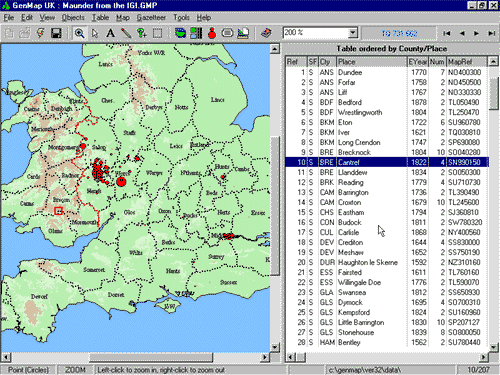
OverviewGenMap UK is a program for UK distribution mapping. You can create maps of historical or genealogical data relating to the British Isles using your own data. It includes a large Gazetteer of British places (with many synonyms based on historical usage), so you don't have to know their locations in advance - GenMap does most of the work for you. The program features several styles of mapping, one of which is the simple Point map or 'Dot-Distribution, shown here (right). You can view some of the other styles on the Mapping Styles page. You can use the links at the top of this page for more information. Current VersionLaunched in 2002 and updated in 2007, 2015, 2018 and 2021, v2.42 of the program incorporates many new features compared with 1997's version 1. If you already have a copy of v1.0, you can read about the improvements in What's New?. You may also want to look at the Supply Details and/or Upgrades pages. ScreenshotHere's a screenshot of the GenMap UK program screen, with a file loaded...
Get started in minutes...When you first get the program, run the slide-show tutorials direct from the CD-Rom. Then, starting from scratch create your first example by adding individual places to a blank map, using the comprehensive gazetteer of towns and villages supplied with the program. Or, using the Import Wizard read in your own databases or Gedcom files, watching while the program automatically extracts the placenames and plots them on the map. Note that importing from files created by LDS Companion is supported directly. And the family history database program Custodian can also generate files that are suitable for importing. Then, switch the display to view the same data as a colourful floodfilled county or Registration District map (the program includes detailed coastline and boundary information for England, Wales, Scotland and Ireland). Zoom and pan to areas of interest, optionally bookmarking them for later use. With a few mouse clicks experiment with colours, symbol shapes and sizes; spice up your maps by including relief (hills and mountains); or try bitmap symbols, using the supplied set or create your own... Prepare the finished map...After scrolling and zooming to define an area of interest, add a descriptive title to the page, and perhaps a key, footnote or scale. Try including text annotations, or make use of the lines/arrows feature. Optionally add county labels or selected placename labels. Finally, print or export...Get great output from your desktop printer, or export your maps to a file for incorporating into a publication. Alternatively create exciting map graphics for your own web pages. See some finished examples on the Gallery Page. Ideal for...Creating surname distributions from the IGI, GRO data or the 1881 census; plotting migration of families. Use for placename studies (e.g. instantly create a map of places with the thorpe or Llan- element); and many other historical mapping projects. And dont be restricted by the supplied placename gazetteer - add any number of your own entries. System RequirementsGenMap UK runs under any 32-bit or 64-bit version of Windows (e.g. Windows XP/Vista/7/8/10/11). The program and sample files together require about 18 Mbytes of disk space. Please Click here for notes on running under Windows Vista and later. updated 2 June 2023 |