Example Maps
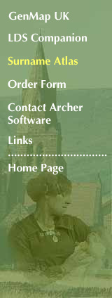
 Here's an example taken straight from the program, this is part of the map for Armstrong, a surname which is found concentrated in the borders region of England and Scotland. The graphic was created by first displaying the basic map, then zooming in to the chosen area. The display was switched from showing Actual Numbers to showing Densities (numbers per 100,000 of the population in each county), and value labels added (the numbers in white boxes). A suitable colour scheme was selected, then the map exported to the clipboard and pasted into PhotoShop. It was slightly cropped and the sea area made transparent. Finally it was saved in GIF format, ready for this web page. Printed directly from the program, you'll get the higher resolution that your printer is capable of. Here's an example taken straight from the program, this is part of the map for Armstrong, a surname which is found concentrated in the borders region of England and Scotland. The graphic was created by first displaying the basic map, then zooming in to the chosen area. The display was switched from showing Actual Numbers to showing Densities (numbers per 100,000 of the population in each county), and value labels added (the numbers in white boxes). A suitable colour scheme was selected, then the map exported to the clipboard and pasted into PhotoShop. It was slightly cropped and the sea area made transparent. Finally it was saved in GIF format, ready for this web page. Printed directly from the program, you'll get the higher resolution that your printer is capable of.
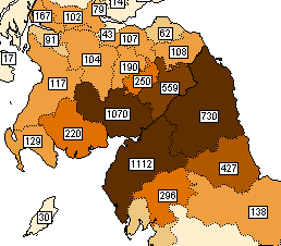
 This second example is part of the map for Crowfoot, with the data aggregated this time by Poor Law Union. The greater level of detail works well here with this well-focussed East Anglian distribution. The darkest parts of the map is the Loddon poor law union, with 182 Crowfoots per 100,000 of the population. This second example is part of the map for Crowfoot, with the data aggregated this time by Poor Law Union. The greater level of detail works well here with this well-focussed East Anglian distribution. The darkest parts of the map is the Loddon poor law union, with 182 Crowfoots per 100,000 of the population.
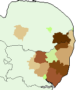
 Now a Cornish surname, Truscott, with the numbers again aggregated by Poor Law Union. This surname barely occurred anywhere outside the south west of England. The names of the unions have been added, also the number of occurrences in each. Now a Cornish surname, Truscott, with the numbers again aggregated by Poor Law Union. This surname barely occurred anywhere outside the south west of England. The names of the unions have been added, also the number of occurrences in each.
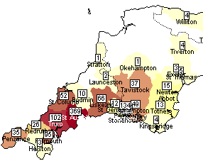
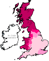 The program isn't restricted to surnames. Here's an example of a forename distribution, this one is a density map for Margaret revealing very clearly its popularity in Scotland and Wales. The program isn't restricted to surnames. Here's an example of a forename distribution, this one is a density map for Margaret revealing very clearly its popularity in Scotland and Wales.
|